

Transmission lines rarely follow straightforward paths, be they on the ground or in the development process. Routes bend around landowners, habitats, tribal lands, permitting constraints, financing hurdles, and politics, sometimes stalling indefinitely. Yet when we introduce new transmission lines into the planning process, we often analyze a single path under a set of assumptions that cannot account for all the potential known or unknown obstacles. With today’s increasing electricity demand but lagging grid expansion, we cannot risk the costly delays that may arise from prematurely committing to a single route.
The Planning Bottleneck
Least-cost pathing and optimal routing methods are fundamental tools in transmission development analysis. They quantify tradeoffs across terrain and land use, environmental sensitivities, and infrastructure conflicts. But in practice, producing one single ‘best’ corridor often proves to be a limitation in and of itself.
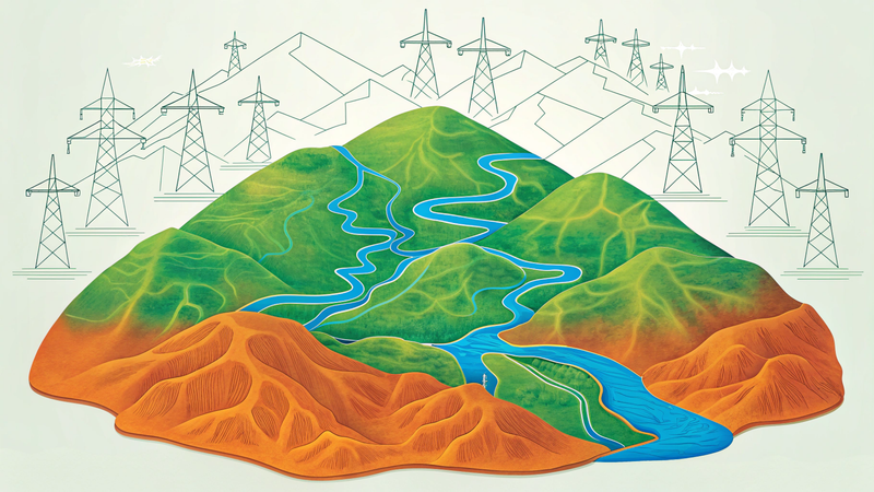
If we imagine optimal pathing to be like water flowing down a mountain taking the course of least resistance, a single optimal path may be the eventual river that forms, and the time it takes to flow to the bottom of the mountain is the cost. Focusing on this path may give us one answer, but examining all the tributaries gives us a much more flexible, deeper understanding of all probable routes down the mountain and just how they may change under different conditions.
Changing the parameters in the modeling is like altering the topography on the mountain. When the topography changes—perhaps the hills represent proximity to certain landowners; hills that once stymied a tributary now liberate the flow of water. The full story becomes clearer when run dozens or hundreds of times, and we start to see tradeoffs where changing variables unveil a fuller landscape.
Conversely, the single-corridor approach breaks down under real-world uncertainty:
- What happens if a key parcel becomes unavailable?
- How costly is it to shift from one route to another?
- Where are the geographic choke points that constrain flexibility?
- Which stretches of a route are robust, and which are fragile?
And given the answers to these questions, critically:
- Who are the local stakeholders and landowners that intersect with priority areas?
The Evolved Solution
Evolved has been developing new GIS-based tools designed to move beyond the single-path paradigm. The process begins by calibrating new sets of ‘guiding multipliers’, which are parameters that influence the direction of a potential transmission line. We then use machine learning to identify a core configuration: rather than a single path, we identify the most-optimal set of variables that define a central route. Importantly, we focus on hard-to-quantify factors such as areas with friction to new development or land ownership (in addition to traditional technical inputs like land cover and slope).
Once we have this ‘perfect’ set of variables, though counterintuitive, we then loosen the constraints and introduce randomness, changing the values in distinct ways through iteration to examine how route structure and cost change as a result. Instead of one line, this results in a spread of a hundred different lines that all accomplish the goal of moving from one point to the other in the cheapest possible (or near-optimal) way. Each reflects a different set of guiding assumptions about land use, resistance, and tradeoffs. Together, they form a distribution of viable pathways across the landscape.
The distribution unveils a dynamic narrative beyond a single optimal path, including:
- Where the geography constrains routing
- Where flexibility exists
- Where small changes in assumptions produce major rerouting
- Where corridors are resilient or brittle
Like the water flowing down the mountain, patterns emerge. Steep valleys constrain transmission lines, but so do roads, conservation areas, farmland patterns, forests, and tribal lands. The initial best solution is often surrounded by a myriad of near-optimal solutions missed only because of the confines of the model. Some routes that appear costly at first open to unexpectedly efficient corridors downstream; others look promising early, only to collapse under slight perturbation. Without investigating these other routes, we may miss the deeper sources and determining factors of better route planning. Transmission path design does not have to be linear; we can plan for adaptability rather than react to disruption.
Finally, in evaluating many alternatives early in the process, we allow for more nimble adjustments and responsiveness to stakeholders. The transmission planning and development process needs all available options to accelerate the deployment of grid assets to meet the urgent new demand requirements at lower cost and set the stage for more diverse and resilient energy systems. By incorporating this advanced new outlook on routing decisions into our modeling and tying power flow with capacity expansion, we envision a novel, holistic set of solutions to transmission complexities.
As we implement and enhance this process, we recognize this new outlook as critical for developers, conservationists, regulators, lawmakers, local organizations or anyone else interested in the intersection of land-use and smarter transmission planning. If any part of this could be helpful to your planning and decision-making, we look forward to connecting.